Back Hiiumaa Afrikaans هييوما Arabic Hiyumaa Azerbaijani Хіюмаа Byelorussian Хіюмаа BE-X-OLD Хиюмаа Bulgarian হিউমা Bengali/Bangla Hiiumaa Breton Hiiumaa Catalan Hiiumaa (pulo) CEB
 Tahkuna peninsula is the northernmost part of Hiiumaa | |
 | |
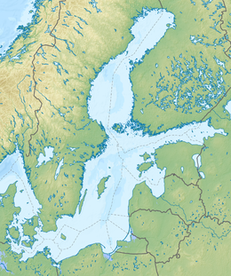
Location within Baltic Sea region | |
| Geography | |
|---|---|
| Location | Baltic Sea |
| Coordinates | 58°53′03″N 22°38′40″E / 58.88417°N 22.64444°E |
| Archipelago | West Estonian archipelago |
| Area | 989 km2 (382 sq mi) |
| Highest elevation | 68 m (223 ft) |
| Highest point | Tornimägi |
| Administration | |
Estonia | |
| County, parish | Hiiu County, Hiiumaa Parish |
| Largest settlement | Kärdla (pop. 3,287 [as of 1 January 2012][1]) |
| Demographics | |
| Population | 9,558 (2019) |
| Pop. density | 9.1/km2 (23.6/sq mi) |
Hiiumaa (US: /ˈhiːʊmɑː, ˈhiːəmɑː/,[2][3] Estonian: [ˈhiːumɑː]) is the second largest island in Estonia and is part of the West Estonian archipelago, in the Baltic Sea. It has an area of 989 km2 and is 22 km from the Estonian mainland. Its largest town is Kärdla. It is located within Hiiu County.[4][5]
- ^ Comparison of self-government units Archived 7 July 2013 at the Wayback Machine, Statistical Council's Regional Portal (checked 7 November 2012)
- ^ "Hiiumaa". Collins English Dictionary. HarperCollins. Retrieved 30 July 2019.
- ^ "Hiiumaa". Merriam-Webster.com Dictionary. Retrieved 30 July 2019.
- ^ "Hiiumaa | island, Estonia". Encyclopedia Britannica. Retrieved 18 April 2019.
- ^ "Hiiumaa". b7.org. Archived from the original on 18 April 2019. Retrieved 18 April 2019.
© MMXXIII Rich X Search. We shall prevail. All rights reserved. Rich X Search


